Platforms: iPhone, iPad, iPod Touch, Apple iPhone OS
Categories: Travel & Navigation
Upload date: 3 Nov 12
Developer: Visual IT
License: Commercial
Price: 0.99 $
Downloads: 17
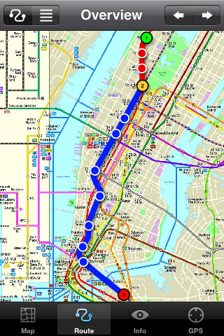
New York Subway by Zuti - The "New York Subway" application is a superb geographically based map and route planner for the New York public transport systems. It also contains a superb animated journey planner to help you get around the Subway, Long Island Rail Road, Metro-North Railroad, New Jersey Transit and a number of ferry services provided by NY Waterway and New York Water Taxi. This application is one in a worldwide series of Zuti maps from Visual IT who have been producing public transportation maps for mobile devices for many years.
MAP
The map is hand drawn by Visual IT and provides a unique geographically based view of the city with many places of interest drawn directly on the background so you can easily get your bearings when traveling in and around the city. You can also use your inbuilt GPS (can also work with iPod Touch devices) to accurately locate and track yourself within the city centre and see the nearest transportation stop and distance to it. This is the only pubic transportation route planner with this ability.
Tap on the map for location information, use the inbuilt search feature or choose from a list of locations. Places of interest, museums, hotels, parks, restaurant, shops, hospitals, streets, etc, are also included. The route planner will automatically suggest the nearest station to any place of interest you select.
NO INTERNET CONNECTION REQUIRED
The map and routing does not require an internet connection and you will not be charged data connection fees. This also means the application runs successfully underground and on an iPod Touch. The only feature that requires an internet data connection is the “Live Info” which is optional and if used only requires a small amount of data.
ROUTING
Does not require an internet connection and will always be available to display a clear and detailed view of the city transport systems, plus list and animate the optimum route for your journey. Provides the fastest route calculations of any mobile routing application (virtually instantaneous) using actual published journey times with the ability to select the quickest route or the route with the least changes.
Comprehensive details of your planned route are provided, including changes, directions of travel, number of stops, predicted journey times, etc. Uniquely this application gives you “direction”, “towards” and “service frequency” information (not available on any other offline journey planner) for example “Take the Red line (Southbound) towards 95th/Dan Ryan for 6 stops. Service runs every 7 minutes” which is essential when finding the correct platform and connection. Also given are alternatives for each leg of the journey.
What's New in This Release:
· Completely new map and routing.
· Many enhancements and added features.
Like it? Share with your friends!
If you got an error while installing Themes, Software or Games, please, read FAQ.
Supported operating systems:
Apple iOS 10.x (iPad), Apple iOS 10.x (iPhone), Apple iOS 11.x (iPad), Apple iOS 12.x (iPad), Apple iOS 12.x (iPhone), Apple iOS 4.2.x (iPad), Apple iOS 4.2.x (iPhone), Apple iOS 4.2.x (iPod Touch), Apple iOS 4.3.x (iPad), Apple iOS 4.3.x (iPhone), Apple iOS 4.3.x (iPod Touch), Apple iOS 5.0 (iPad), Apple iOS 5.0 (iPhone), Apple iOS 5.0 (iPod Touch), Apple iOS 6.0 (iPad), Apple iOS 6.0 (iPhone), Apple iOS 6.0 (iPod Touch), Apple iOS 7.0 (iPad), Apple iOS 7.0 (iPhone), Apple iOS 7.0 (iPod Touch), Apple iOS 8.x (iPad), Apple iOS 8.x (iPhone), Apple iOS 8.x (iPod Touch), Apple iOS 9.x (iPad), Apple iOS 9.x (iPhone), Apple iOS 9.x (iPod Touch)
Similar Software:
London City Maps Lite London City Maps Lite - software that helps you download and store the travel maps and plans you need. This super-handy app lets you download publicly available maps and store them on your iPhone or iPod Touch. You can download the maps when you have fast wifi connection - and then use any time in the future without delay
Up North! Grand Traverse Up North! Grand Traverse - Experience the many faces of the Grand Traverse region with this travel application from Sutro Media - Up North! Grand Traverse.
A Grand Traverse adventure can be a lot of things to different people. For some, Grand Traverse is a vast playground, ripe with opportunities for hiking and biking, camping and fishing, swimming and paddling
Lancaster London (iPhone) Lancaster London (iPhone) - There's one thing that guests at Lancaster London always seem to agree on - the views are breathtaking. With Hyde Park, the largest of the Royal Parks, directly to the south, and vistas east to the City of London, we have arguably the best views in London
London Bus for iPad by Zuti London Bus for iPad by Zuti - The new Zuti London Bus map has finally arrived, making it easy to travel by bus anywhere in central London. This clear and colourful map covers a detailed street level area of 6 miles by 4 miles and includes over 1300 bus stops and 189 bus routes
Beijing Street Maps Beijing Street Maps - software that helps you download and store the travel maps and plans you need. This super-handy app lets you download publicly available maps and store them on your iPhone or iPod Touch. You can download the maps when you have fast wifi connection - and then use any time in the future without delay
TransitGuru Maryland MTA The only transit app that combines with offline schedule, system maps, multiple transit types (train or bus) or agencies for single metro area, alarm to wake you up when arrival, and integration with Yelp and Map
Detroit Maps Detroit Maps software that helps you download and store the travel maps and plans you need. This super-handy app lets you download publicly available maps and store them on your iPhone or iPod Touch. You can download the maps when you have fast wifi connection - and then use any time in the future without delay
Canberra Bus Canberra Bus is a friendly timetable application that provides bus timetable for Canberra bus transport commuters. If you need an application to keep track of your favorite bus timetables throughout Canberra then this is for you!
· Access to all timetables in Canberra, Australia.
· Save and remove favorite routes at the touch of a button
TransitM&S Nashville TransitM&S Nashville - TransitM&S is an easy-to-use transit application that provides bus info for Nashville's MTA.
The app is designed for offline use. It is ideal for iPod Touch users. Even for iPhone users, it is designed to save money because AT&T no longer offers the unlimited data plan
Orlando Maps Orlando Maps - software that helps you download and store the travel maps and plans you need. This super-handy app lets you download publicly available maps and store them on your iPhone or iPod Touch. You can download the maps when you have fast wifi connection - and then use any time in the future without delay
Other Software by developer «Visual IT»:
Tube San Francisco Pro for Palm OS Tube San Francisco Pro for Palm OS - This map package for Tube 2 consists of a fully scrollable detailed map of the San Francisco metro & rail systems and linked high quality street maps of central San Francisco
Rough Guides Map Washington DC Rough Guides Map Washington DC... These guides are a series of fantastic interactive maps.
Produced in conjunction with the premier travel publisher Rough Guides.
Discover and explore Washington DC using full colour interactive linked maps, in this simple to use PDA version of The Rough Guides Washington DC
London Underground by Zuti London Underground by Zuti - "London Underground 10" is a superb map and route planner for the London Underground, Overground and Docklands Light Railway (DLR) services. So you can make a quick exit when you leave the train we have now added exit information for all stations on the London Underground
Tube 2 New York City (Palm OS) Tube 2 New York City (Palm OS) - This map package for Tube 2 consists of a fully scrollable detailed map of the New York City MTA subway system.
Plan journeys on this system, list details of the quickest routes and see a superb animated display of your journey tracking around the system map
Tube Miami (Series 60) Tube Miami (Series 60) - Our highly acclaimed Tube application that guides you around the metro and rail system of Miami is now available for your Series 60 Symbian powered phone. An essential addition to your phone for locals and tourists alike.
· A detailed clear colour map of the Miami metro & rail system fully scrollable.
· Quick find station utility
Tube Moscow (UIQ) Tube Moscow (UIQ) - Our award winning and highly acclaimed application that guides you around the complex metro system of Moscow is now available for your Symbian UIQ phone.
An essential addition to your P800 / P900 / P910 if you travel in or around this city
· A detailed clear colour map of the Moscow metro system fully scrollable
Tube 2 Amsterdam Pro (UIQ3) Tube 2 Amsterdam Pro (UIQ3) - This map package for Tube 2 consists of a fully scrollable detailed map of the Amsterdam tram & metro system and linked street maps of central Amsterdam.
Plan journeys on the tram & metro system, list details of the quickest routes and see a superb animated display of your journey tracking around the system map
Tube 2 Melbourne (UIQ3) Tube 2 Melbourne (UIQ3) - This map package for Tube 2 consists of a fully scrollable detailed map of the Melbourne metro & rail system.
Plan journeys on this system, list details of the quickest routes and see a superb animated display of your journey tracking around the system map
Tyne & Wear Metro for iPad by Zuti Tyne & Wear Metro for iPad by Zuti - The new Tyne & Wear Metro map makes it easy to travel in and around the city using the Nexus Metro system. Unlike old fashioned schematic style maps this product contains a geographically accurate central area showing major streets, parks and places of interest etc, allowing the user to easily get their bearings
Tube 2 Portland (UIQ) Tube 2 Portland (UIQ) - This map package for Tube 2 consists of a fully scrollable detailed map of the Portland rail system.
Plan journeys on this system, list details of the quickest routes and see a superb animated display of your journey tracking around the system map


")


")
")
")
")
")

")