Platforms: iPhone, iPad, iPod Touch, Apple iPhone OS
Categories: Travel & Navigation
Upload date: 29 Jun 11
Developer: Weather Decision Technologies
License: Commercial
Price: 3.99 $
Downloads: 66
iStormCenter gives you immediate access to the latest news on hurricanes, straight to your iPhone from the experts at the National Hurricane Center.
iStormCenter gives you exclusive video reports and video briefings from hurricane specialists at the National Hurricane Center as well as the most up-to-date conditions and breaking news.
You can follow through all the stages of a hurricane starting with updates when conditions are ripe for a tropical disturbance, then the progression into a tropical depression.
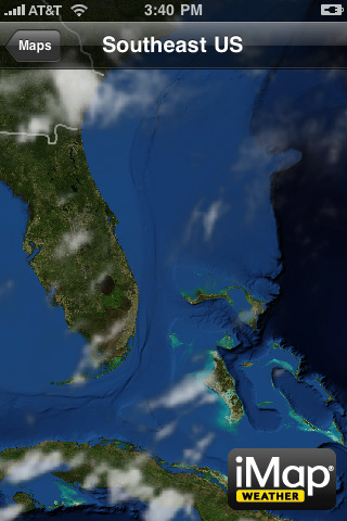
Track the hurricanes in real time and follow the predicted paths, including vital statistics on predicted wind strength as the news breaks with briefings from the National Hurricane Center. You can explore interactive tracking maps, detailed radar and satellite images and watch recently completed video briefings. Or you can look at past hurricanes by date and location for a preview of things to come.
Use iStormCenter to be the first to know and then update family, friends and co-workers on the latest hurricane developments.
Disclaimer – iStormCenter attempts to keep you updated with the latest information about the tropical weather situation. All official hurricane data originates from the National Hurricane Center. It is our goal to provide you with the best information available, however, do not make decisions or take actions solely based on this application that would impact the safety and/or well-being of yourself or others in your care. iStormCenter cannot guarantee the precision, accuracy and latency of the data or information provided. Nor do we have control of the network connection that could directly impact the timeliness of the information communicated.
Maps:
· Simply select active storms from the Maps menu to get the current location statics, forecast track, error fan and wind speed forecasts.
· Use the zoomable radar map to zoom to see areas being impacted by the storm.
· View several regions via detailed satellite images to get the latest views of the tropics.
Videos:
· You can watch the latest videos and eye-witness reports on the tropical situation from inception to the devastating wind and dangerous flooding in low-lying area.
· Hurricane history is at your fingertips, by choosing the year you can view the hurricane and tropical storm tracks for the Atlantic Basin.
Updates:
· Up-to-the-minute text and video information is delivered from the National Hurricane Center including the latest video briefings and the most informative reports from the forecasters at NHC.
Like it? Share with your friends!
If you got an error while installing Themes, Software or Games, please, read FAQ.
Supported operating systems:
Apple iOS 10.x (iPad), Apple iOS 10.x (iPhone), Apple iOS 11.x (iPad), Apple iOS 12.x (iPad), Apple iOS 12.x (iPhone), Apple iOS 4.0.x (iPhone), Apple iOS 4.0.x (iPod Touch), Apple iOS 4.2.x (iPad), Apple iOS 4.2.x (iPhone), Apple iOS 4.2.x (iPod Touch), Apple iOS 4.3.x (iPad), Apple iOS 4.3.x (iPhone), Apple iOS 4.3.x (iPod Touch), Apple iOS 5.0 (iPad), Apple iOS 5.0 (iPhone), Apple iOS 5.0 (iPod Touch), Apple iOS 6.0 (iPad), Apple iOS 6.0 (iPhone), Apple iOS 6.0 (iPod Touch), Apple iOS 7.0 (iPad), Apple iOS 7.0 (iPhone), Apple iOS 7.0 (iPod Touch), Apple iOS 8.x (iPad), Apple iOS 8.x (iPhone), Apple iOS 8.x (iPod Touch), Apple iOS 9.x (iPad), Apple iOS 9.x (iPhone), Apple iOS 9.x (iPod Touch), Apple iPhone OS 3.1.x, Apple iPhone OS 3.1.x (iPod Touch), Apple iPhone OS 3.2.x (iPad)
Similar Software:
Wind NOAA Wind NOAA - realWind provides you with a wind forecast for any locations on Earth!
For kitesurfers, windsurfers, surfers, sailors, and paragliders:
· The real time observations, so you know what's going on!
· And accurate forecasts, so you can always find the best conditions for your sport!
No need to figure out your Lat, Long or Zip Code
Earth-Now Earth-Now - NASA's Earth Now is an app that visualizes recent global climate data from Earth Science satellites, including surface air temperature, carbon dioxide, carbon monoxide, ozone, and water vapor as well as gravity and sea level variations. Data sets are visually described using "false color" maps
Fuerth World Travel Fuerth World Travel - Map with locate me function makes you free to move.
Background reading always accompanies you on your trip
Q13FOX Sun Tracker Q13FOX Sun Tracker - Need sunshine? Follow our Sun Tracker and find out when you'll need to apply sunscreen again. Plus, get instant Seattle and Puget Sound weather reports and forecasts with interactive/satellite maps, video, and warnings
WthrDial WthrDial - WTHR is a simple and beautiful weather app for iPhone. Built on Dieter Rams' 10 principles of design, WTHR gives you weather information at a glance, without complicated weather radars or atmospheric pressure readings. WTHR lets you spend more time enjoying the weather rather than watching it
Catania World Travel Catania World Travel - Map with locate me function makes you free to move.
Background reading always accompanies you on your trip
The Weather Channel Max (iPhone) The Weather Channel Max (iPhone) - The Weather Channel Max delivers the weather tools you need to plan your day, week or even the next hour. Using patented ultra-local TruPoint weather technology, The Weather Channel is the only weather provider to provide future radar, so you'll know where the storm is heading, not just where it's been
Charleroi World Travel Charleroi World Travel - Map with locate me function makes you free to move.
Background reading always accompanies you on your trip
A+ Voice Thermometer A+ Voice Thermometer - Finally a location based thermometer for your device, either in Fahrenheit or Celsius.
Just touch the cell of the time that you want the temperature forecast and the app will tell you the temperature using TEXT TO SPEECH technology
5NEWS Weather 5NEWS Weather - Garrett's 5i Interactive severe weather center is a full featured weather application with the tools to keep you informed of weather news, current conditions and forecasts. The Max 5 Interactive Map provides an up-to-date map of precipitation anywhere in the U.S
Other Software by developer «Weather Decision Technologies»:
5NEWS Weather 5NEWS Weather - Garrett's 5i Interactive severe weather center is a full featured weather application with the tools to keep you informed of weather news, current conditions and forecasts. The Max 5 Interactive Map provides an up-to-date map of precipitation anywhere in the U.S
StormTroopers StormTroopers gives you immediate access to the latest news and videos on extreme storms across the United States.
StormTroopers gives you exclusive behind-the-scenes video reports and video briefings from the leaders in storm chasing, TornadoVideos.net (TVN)
WHNT News 19's iPad Weather App HD WHNT News 19's iPad Weather App HD - WHNT News 19's iPad Weather app is your information center for weather where you live. It has weather tools designed to keep you aware of the latest weather forecasts and advisories, current conditions, warning information and 7-day and extended outlooks
FOX 17 Weather FOX 17 Weather - With the FOX 17 weather app, you'll have the latest forecasts and reports on current conditions for Grand Rapids and West Michigan. The FOX 17 weather application also includes an interactive weather map that allows you to see radar and current conditions for any location you pick
iMapWeather Lite iMapWeather Lite - iMapWeather is a sophisticated weather application that delivers the best interactive radar map on the iTunes store.
The application displays up-to-date, detailed information in the form of radar and clouds (satellite) on an interactive map, along with current conditions, 7 day, and hourly forecasts.
Receive timely weather alerts for your active location
iMap Weather iMap Weather Built upon state-of-the-science technologies, this multimedia weather platform provides location-based radar images, lighting strikes, current conditions and forecasts and allows you to pre-set additional locations of interest
iMapRadar iMapRadar is a simple weather application that delivers the best interactive radar map on the iTunes Store. iMapRadar displays up-to-date, detailed information in the form of radar and clouds (satellite) on an interactive map along with current conditions, full 7 day, and hourly forecasts. Bookmarks allow you to save up to 5 locations with multiple pins on the map
WNEP Stormtracker 16 Weather WNEP Stormtracker 16 Weather - WNEP Weather is a full featured weather application with the tools to keep you informed of weather news, current conditions and forecasts. The interactive Radar Map provides radar and current conditions everywhere in our viewing area
NewsChannel 3 Live VIPIR Radar NewsChannel 3 Live VIPIR Radar - NewsChannel 3's Live VIPIR Radar is a full featured weather application with the tools to keep you informed of weather news, current conditions and forecasts. The interactive VIPIR radar map provides an up-to-date map of precipitation for anywhere in the U.S. Just type your favorite location to see radar, information and current conditions
Q13FOX Sun Tracker Q13FOX Sun Tracker - Need sunshine? Follow our Sun Tracker and find out when you'll need to apply sunscreen again. Plus, get instant Seattle and Puget Sound weather reports and forecasts with interactive/satellite maps, video, and warnings


")


