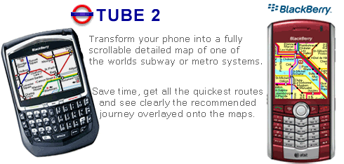
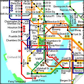
Transform your Blackberry into a fully scrollable detailed map of the New York City MTA subway system.
Plan journeys on the New York City subway system, have the quickest routes to hand, with all the details you need including line changes, platform directions and accurate journey times.
See a clear informative display of the route overlaid on the system map. The journey overlay indicates the direction of travel, the colour code of the line your travelling on, and where to make changes along your journey.
Only $10.00
One of a series of Tube 2 product from Visual IT, many cities from all around the world are available.
Like it? Share with your friends!
Supported operating systems:
RIM BlackBerry OS 2.0, RIM BlackBerry OS 3.x, RIM BlackBerry OS 4.0, RIM BlackBerry OS 4.1, RIM BlackBerry OS 4.5, RIM BlackBerry OS 4.6, RIM BlackBerry OS 4.7, RIM BlackBerry OS 5.0
Similar Software:
NavFunPro NavFunPro is the most universal Google-Maps tool that gives you all the goodies of Google Maps and Google Earth. You can connect your Bluetooth GPS or use the mobile's built in GPS. Then NavFunPro turns your mobile into an all-terrain navigation/gps tool. All your tracks are uploaded to internet. You can check them out at www.trackthisout.com/tm
US Town By ZIP reference for BlackBerry US Town By ZIP reference for BlackBerry - In USA, one may often have problems telling the postal code of his own Town. Anyone using regular snail mail surely already knows the pain of having to look up postal codes. If you need to look up ZIP codes often and on the go, then this reference dictionary is just for you
GPSed Pro GPSed Pro- is a service for trip tracking from mobile. In real time tracks are traced on Google maps and stored in an online archive. With a simple geotagging feature it is possible to pin photos to a map precisely at a place they were taken
MetrO (BlackBerry) Métro is your free guide to public transport systems worldwide (about 400 cities covered now)
NavFunPro NavFunPro - NavFun Pro is the ideal navigation/maps tool that gives you all the goodies of a full featured GPS receiver and Google Maps, Earth, Terrain. Ideal for hiking, geocaching, skiing, mountain biking, and city tours
WorldMate Live Gold Annual Subscription WorldMate Live Gold Annual Subscription-Keep a personal travel assistant in your pocket! WorldMate Live will manage your full itinerary, including travel arrangements and business meetings, making all details immediately accessible on your mobile device, and ensure a smooth trip by pushing alerts regarding imminent events like flight delays
ContactMapper Geocodes your contacts from the address book and shows them on a satellite or topographic map. The 2-click-on-map-application!
TUBE 2 Paris (Blackberry) TUBE 2 Paris (Blackberry)
Tube 2 Paris
Transform your Blackberry into a fully scrollable detailed map of the Paris Metro system.
Plan journeys on the Paris Metro system, have the quickest routes to hand, with all the details you need including line changes, platform directions and accurate journey times
Other Software by developer «Visual IT»:
Tube 2 Chicago (Palm OS) Tube 2 Chicago (Palm OS) - This map package for Tube 2 consists of a fully scrollable detailed map of the Chicago metro & commuter rail system.
It includes the rapid transport system of subway and elevated lines, in addition to the many commuter rail lines. The map also indicates how the Amtrak intercity routes intersect with the cities transport network
Tube Paris Pro (2009 Edition) Tube Paris Pro
New release with GPS support.
Tube plans all your journeys for you on the Paris metro & RER systems. It gives you the quickest routes, detailed on what trains to take and in what direction plus, service running times, fare zones, ticketing information and lots more...
Tube 2 Engine Pocket PC Tube 2 Engine - Transform your PDA into a fully scrollable detailed map of one of the worlds subway or metro systems.
See your journeys come alive with a superb animated display.
Save hours by automatically having the quickest routes to hand, with all the details you need including line changes, platform directions and accurate journey times
Tube 2 Portland (UIQ) Tube 2 Portland (UIQ) - This map package for Tube 2 consists of a fully scrollable detailed map of the Portland rail system.
Plan journeys on this system, list details of the quickest routes and see a superb animated display of your journey tracking around the system map
Washington Metro for iPad by Zuti Washington Metro for iPad by Zuti - The new Washington Metro 10 map makes it easy to travel in and around the city using the WMATA Metro, MARC and VME systems. Also included are the Potomac river taxi routes and the DC Circulator bus routes
Tube 2 Paris (Palm OS) Tube 2 Paris (Palm OS) - This map package for Tube 2 consists of a fully scrollable detailed map of the Paris metro and RER system.
Plan journeys on this system, list details of the quickest routes and see a superb animated display of your journey tracking around the system map.
A Pro version is also available with integrated high quality street maps of central Paris
Tyne & Wear Metro for iPad by Zuti Tyne & Wear Metro for iPad by Zuti - The new Tyne & Wear Metro map makes it easy to travel in and around the city using the Nexus Metro system. Unlike old fashioned schematic style maps this product contains a geographically accurate central area showing major streets, parks and places of interest etc, allowing the user to easily get their bearings
Tube Philadelphia (Palm OS) Tube Philadelphia (Palm OS) - An award winning and highly acclaimed Palm OS application that guides you around the complex rail system of Philadelphia. An essential addition to your Palm device for locals and tourists alike.
Tube's features include:
A detailed clear colour (or grey scale) map of the transport system fully scrollable.
Quick find station utility
Tube 2 Los Angeles (UIQ) Tube 2 Los Angeles (UIQ) - This map package for Tube 2 consists of a fully scrollable detailed map of the Los Angeles rail system.
Plan journeys on this system, list details of the quickest routes and see a superb animated display of your journey tracking around the system map
Rough Guides Map Amsterdam Rough Guides Map Amsterdam... These guides are a series of fantastic interactive maps.
Produced in conjunction with the premier travel publisher Rough Guides.
Discover and explore Amsterdam using full colour interactive linked maps, in this simple to use PDA version of The Rough Guides Amsterdam


")


 Transform your Blackberry into a fully scrollable detailed map of the New York City MTA subway system.


")


")
")
")

")

")

")
")
