Orientation, Routing, Tracklogs, Waypoint and POI management.
Navigate with Spot:
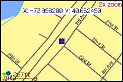
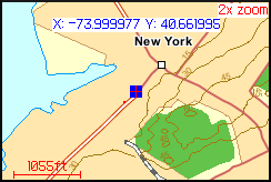
Using Moving Map Navigation, the map centeres current position and will therefore move with you. This makes it easy for you to navigate visually in your environment. You can either do that with street level maps or in remote areas with maps composed of satellite photos.
You can as well use Spot's routing feature for navigation. It will guide you to a waypoint and gives you information on the distance, estimate time of arrival etc.
Routing
Streetlevel Map
Outdoor Activites:
Spot can be used for a wide range of outdoor activities. You can add waypoints/POIs (Point of Interest) to mark you favorite locations or download them from the internet. They will be visualized on the map of your device and simplifies orientation wherever you are.
A built-in tracklogger draws the distance you covered on the map. The Elevation screen will visualize the elevation profile of your track.
Tracklog
Position Info
Track Elevation
Satellite Info
Field Navigation:
Spot can perfectly be used for Field Naviation with your Blackberry, you do not need any additional hardware.
It can be easily integrated into your company GIS environment due to interoperable industry standard interfaces implemented in Spot. You can get field maps from your company GIS or from public map services. The waypoint management system allows you to add additional data in the field. For more information on how to integrate Spot with your company GIS or on how to use your company geodata with Spot, please write an e-mail to: info@skylab-mobilesystems.com.
Field Navigation
Map Navigation
The GPX waypoint format support assures an easy to use waypoint exchange and a trouble-free integration into other applications.
Our unique combination of GPS positioning and WMS map server access allows you to navigate on the map of your choice, available from the endless pool of free WMS servers.
Like it? Share with your friends!
Supported operating systems:
RIM BlackBerry OS 4.5, RIM BlackBerry OS 4.6, RIM BlackBerry OS 4.7, RIM BlackBerry OS 5.0
Similar Software:
Qibla Compass Pro for Mobiles Qibla Compass Pro for Mobiles - Finding the Qibla direction from anywhere in the world was never easier before! With Qibla Compass not only do you get Qibla direction from True North but with an even more accurate method of determining the Qibla direction from the current position of the Sun, you always know what direction to face
Foyage Foyage - Wherever you go, Foyage is your personal radar. !
Works only in Singapore & Indonesia !!!
Features include :
* current position is auto-update and shown in road name
* more than 12,000 location information in Singapore & Indonesia; including petrol kiosk, atm, restaurant, cafe, bakery, fast food, food stall, nursing room, post office, etc
GOTS Tracking Agent GOTS Tracking Agent - The GOTS Tracking Agent turns your BlackBerry® into a tracking device. All Positions are stored on a central server that you can access with your personal login. In your web browser you can easily display the current position or trip histories. The BlackBerry® will also display your surroundings as a map
FON Access Points for Andorra FON Access Points for Andorra - FON offers you a new Points of Interest service (POIs). This allows you to download FONspots directly to your navigation device.
What does that mean? You can download a Points of Interest file directly to your navigation device
GPS Test This application determines your current GPS position, also display the accuracy of the GPS sensor and can display your position on a map
My Anchor Watch for BlackBerry My Anchor Watch for BlackBerry - The 'My Anchor Watch' montitors your boat's position to ensure that your anchor is not dragging away from its location on the bottom.
If the anchor drags, the program sounds alarms or alerts you with SMS to another phone.
'My Anchor Watch' uses the phones internal GPS to monitor the position
Smart Tracker Smart Tracker is a real-time tracking service using your BlackBerry® to share your location and record tracks for later analysis.
For instructions on how to obtain a access and set up tracking on your BlackBerry®, please contact you provider
FON Access Points for Morocco FON Access Points for Morocco - FON offers you a new Points of Interest service (POIs). This allows you to download FONspots directly to your navigation device.
What does that mean? You can download a Points of Interest file directly to your navigation device
Trapster Trapster - Your GPS enabled BlackBerry device alerts you as you approach police speed traps
FON Access Points for Fiji FON Access Points for Fiji - FON offers you a new Points of Interest service (POIs). This allows you to download FONspots directly to your navigation device.
What does that mean? You can download a Points of Interest file directly to your navigation device
Other Software by developer «Skylab Mobilesystems Ltd.»:
ContactMapper Geocodes your contacts from the address book and shows them on a satellite or topographic map. The 2-click-on-map-application!
Spot Spot - Geocaching, hiking, biking, outdoor activities. Combine the power of GPS with worldwide maps and a flexible waypoint management. Orientation and routing enables you to find interesting places, store and share them with others
TopoExplorer for Touch Screen Devices ONLY TopoExplorer for Touch Screen Devices ONLY
Features | Free Download
With TopoExplorer you will discover your surroundings on topographic maps even in remote areas assisted by GPS and without the need of the wireless network connection
GPS Waypoint Manager - Free BETA GPS Waypoint Manager - Free BETA - The GPS Waypoint Manager for BlackBerry® Smartphones is a comprehensive tool for managing waypoints and points of interests (POI) right on your phone. By using the GPS in your device, your can accurately pin-point your location and map out other points as well. You also have the ability to import/export .kmz and
MobileTracker MobileTracker
The tracklog application for mobile devices!
Records a tracklog.
Elevation can be tracked.
Configurable timespan between positions.
Extensive statistical information
Spot for BlackBerry (OS 4.2) Spot combines your BlackBerry and Bluetooth GPS receiver into the most powerful positioning tool
GPS SightFinder GPS SightFinder looks for sights, landmarks and other interesting places close to your current location. Descriptive search results with thumbnail images link to the corresponding Wikipedia articles for detailed up-to-date information.
GPS SightFinder is a Windows Mobile application for Smartphones and PocketPCs with built-in GPS or a connected Bluetooth GPS device
TopoExplorer for Non-Touch Screen Devices ONLY TopoExplorer for Non-Touch Screen Devices ONLY
Features | Free Download
With TopoExplorer you will discover your surroundings on topographic maps even in remote areas assisted by GPS and without the need of the wireless network connection
LocalWeather LocalWeather is an application for Windows Mobile Smartphones and PocketPCs providing location-based weather information. It retrieves the current location from a GPS receiver, looks up the nearest weather station and fetches information on the current weather conditions from the Internet
")


")


