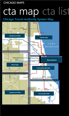
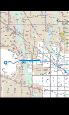
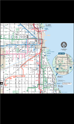
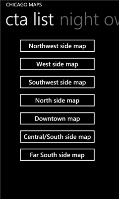
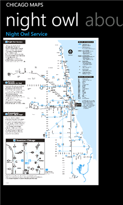
Chicago Maps - Offline (no data connection necessary!) public transportation maps for the Chicago area. Click on the thumbnails and zoom in for a detailed look.
Includes:
1. an overview of the Chicago Transit Authority system with the ability to zoom into different sections using a map and/or a list
2. Night Owl bus map
Can be used in portrait or landscape view.
Like it? Share with your friends!
If you got an error while installing Themes, Software or Games, please, read FAQ.
Supported operating systems:
Windows 10 Mobile, Windows Phone 7, Windows Phone 8
Similar Software:
Vicinity Vicinity automatically locates you and businesses within 1 mile of you, providing 0 click access to everything in your Vicinity. Selecting a search result presents you with a detailed view, including a zoomable map with walking route from your current location
Bingle Maps Bingle Maps is a full featured map application. Other than the commonly desired features like Search, Routing and Itineraries, it allows you to drop unlimited personal pins and synchronize them with your DropBox account, not to mention that it also integrates with Google Maps.
Highlights:
- You can choose to use either Bing Maps or Google Maps
NaMap NaMap - The primary text of the application NaMap is in English and Korean.
English Description:
"Namap" application provide map information providing by Naver Open API
GMaps GMaps - Free Google Maps for Windows Phone 7
Now available the following features:
1. Map navigation with different layers support
2. GPS tracking
3. "What is here"
4. Search for location
We appreciated your feedback
Canada Topography Canada Topography - provides topographic information for the entire country of Canada. The maps provide details such as altitude, railways and numerous other layers. Using the GPS you can center on your current location and even zoom to specific areas of the country.
All maps are provided by Geocratis Canada (http://www.geogratis.gc.ca/geogratis/en/service/toporama
Free World Explorer Free World Explorer - So, you think you are good at geography? Let's see how good you are :)
Pan the map to fly the plane to the destination place and click on land button when you find the green airport symbol. You need to be connected to internet for this. Difficulty mode to challenge you with a lot more countries
SketchMaps Free! SketchMaps Free! - SketchMaps is the very first drawable live map which can also be saved to pictures. It's an unique idea and it's first of its kind. It's that simple. Please, view screenshots!
SketchMaps Free is full-featured, but will show ads. You can buy the full version of SketchMaps at any time to remove the ads
GMapPro GMapPro - Features:
1. Use Google Maps which is the most complete mapping solution available in the world
2. Download the maps of desired area, and use them while you are offline
3. Provide a list of downloads so you can delete them in future (if you don't wish to keep them anymore)
4. Use the phones internal GPS, to find you on the map
5. Markers:
5
AGMapTime AGMapTime is a simple viewer with time slider features for "time-aware" layer data of ArcGIS services. Time slider lets you browse map features on specific time. You can view various kind of map layers from ArcGIS.com or your own ArcGIS server.
version 0.5 (First version)
- Only supports dynamic layer.
- Fixed base map.
- Slider auto detect time duration
Other Software by developer «Pegus Co»:
Austin Facts Austin Facts - Austin Facts app features information about Austin, Texas in the following 11 sections:
1. About Austin, Texas
2. History
3. Geography
4. Climate
5. Demographics
6. Economy
7. Attractions
8. Sports
9. Government
10. Education
11
San Antonio Facts San Antonio Facts - San Antonio Facts app features information about San Antonio, Texas in the following 11 sections:
1. About San Antonio
2. History
3. Geography
4. Climate
5. Demographics
6. Economy
7. Attractions
8. Sports
9. Government
10. Education
11
San Jose Facts San Jose Facts - San Jose Facts app features information about San Jose, California in the following 11 sections:
1. About San Jose
2. History
3. Geography
4. Climate
5. Demographics
6. Economy
7. Attractions
8. Sports
9. Government
10. Education
11
New York City Facts New York City Facts - New York City Facts app features information about New York City, NY in the following 13 sections:
1. About New York City
2. Geography
3. Climate
4. Architecture
5. Boroughs
6. Entertainment
7. Tourism
8. Media
9. Cuisine
10. Sports
11. Economy
12. Demographics
13
Indianapolis Facts Indianapolis Facts - Indianapolis Facts app features information about Indianapolis, Indiana in the following 11 sections:
1. About Indianapolis
2. History
3. Geography
4. Climate
5. Demographics
6. Economy
7. Attractions
8. Sports
9. Government
10. Education
11
3-2-1 Math Bet! Free 3-2-1 Math Bet! Free - One of the main features allows you to set how many score points you want to risk in each round
Charlotte Facts Charlotte Facts - Charlotte Facts app features information about Charlotte, North Carolina in the following 11 sections:
1. About Charlotte, North Carolina
2. History
3. Geography
4. Climate
5. Demographics
6. Economy
7. Attractions
8. Sports
9. Government
10. Education
11
Philadelphia Facts Philadelphia Facts app features information about Philadelphia, PA in the following 12 sections:
1. About Philadelphia
2. Geography
3. Climate
4. Crime
5. Neighborhoods
6. Culture
7. Education
8. Media
9. Sports
10. Economy
11. Demographics
12
Boston Maps Boston Maps - This app contains offline public (no data connection necessary after first download) transportation maps for the Boston area.
Includes
subway
commuter rail
commuter boat
water taxi
Boston detail maps
MBTA system maps
Can be used in portrait or landscape view