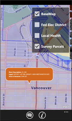
GeoBC Showcase - This app takes advantage of geospatial layers provided by GeoBC. It will include Federal Electoral Districts and Local Health areas plus Primary Survey Parcels in British Columbia, Canada.
Select one of the layers from the list, then press a point on the map and hold to get information about that geographical point.
Like it? Share with your friends!
If you got an error while installing Themes, Software or Games, please, read FAQ.
Supported operating systems:
Windows 10 Mobile, Windows Phone 7, Windows Phone 8
Similar Software:
FidMe FidMe - Toutes vos cartes de fidélité réunies sur votre mobile !
FidMe, le portecarte mobile pour vos cartes de fidélité !
Innovante et simple à utiliser FidMe : enregistrez vos cartes de fidélité en quelques secondes
SketchMaps Free! SketchMaps Free! - SketchMaps is the very first drawable live map which can also be saved to pictures. It's an unique idea and it's first of its kind. It's that simple. Please, view screenshots!
SketchMaps Free is full-featured, but will show ads. You can buy the full version of SketchMaps at any time to remove the ads
Pocket World Free Pocket World Free is your ultimate pocket guide for over 240 countries around the world. The app that puts the whole world on your fingertips. This free version is full featured, supported by ads
GMapPro GMapPro - Features:
1. Use Google Maps which is the most complete mapping solution available in the world
2. Download the maps of desired area, and use them while you are offline
3. Provide a list of downloads so you can delete them in future (if you don't wish to keep them anymore)
4. Use the phones internal GPS, to find you on the map
5. Markers:
5
Bing Get Me There Bing Get Me There - Bing Get Me There is a London travel app that gets you from where you are right now to wherever you want to be. True door-to-door directions using Bing maps and live tube updates to ensure you get the best route for you
AGMapTime AGMapTime is a simple viewer with time slider features for "time-aware" layer data of ArcGIS services. Time slider lets you browse map features on specific time. You can view various kind of map layers from ArcGIS.com or your own ArcGIS server.
version 0.5 (First version)
- Only supports dynamic layer.
- Fixed base map.
- Slider auto detect time duration