Symbian OS | Pocket PC | Smartphone | Android | BlackBerry | Apple iPhone OS | Java | Mobile Gaming | Linux | Palm | Win CE | Tablet  
     

Free Mobile Software, Themes, Games, Apps for PDA and Smartphones

     
Search by Device
My Device

  
Search by Category
Business & Profession
Databases
Dictionary & Translator
Entertainment
Finance
Games
Healthcare & Medicine
Internet & Communications
Multimedia & Graphics
Organisation & Productivity
Programming & Development
Reading
Science & Education
System Utilities
Themes & Wallpapers & Skins
Travel & Navigation
Geocaching
GPS
Guides
Maps
Measuring & Compass
Travel Planning
Weather
Worldtime
More
Search by Platform
Android
Apple iPhone OS
iPad
iPhone
iPod Touch
BlackBerry
Java
Linux
Maemo Nokia Internet Tablet
MeeGO
Sharp Zaurus
Mobile Gaming
Nintendo DS
Playstation 3
Playstation Portable
Wii
Xbox 360
Palm OS
Symbian OS
Series 60
Series 80
Series 90
UIQ
Tablet PC
Windows CE.NET
Windows Mobile Pocket PC
Windows Mobile Smartphone


Achivx Partner
 
 
REALTRACK MOBILE POCKETPC


REALTRACK MOBILE POCKETPC
Version: 1.0

Platforms: Pocket PC


Categories: Travel & Navigation

Upload date: 13 Aug 11

Developer: CYMONLINE

License: Shareware

Price: 89.00 $

Downloads: 38

File Size: 20596 Kb


Download Free Trial of REALTRACK MOBILE POCKETPC 


Rating: 1.0/5 (Total votes: 2)


Realtrack Mobile 1.5 PocketPC

RealTrack Mobile is a mobility solution (Fleet Management and mobile devices tracking Comprehensive System, via GPS through GPRS or WIFI, and through INTERNET access) made up of a set of applications, which allow the user to remotely track any person or object carrying a mobile device of the PDA PocketPC type, and the most important aspect is that this information is given in real time.

The system consists of a server software or Control Centre ?RealTrack Mobile Server?, and the application for mobile devices ?Realtrack Mobile PocketPC?, which are client applications of the Control Centre.

RealTrack Mobile offers, moreover, an innovative utility, the compatibility with Google Earth; with that, apart from viewing the location in one of the best, real cartographies in the market, it has another advantage: several users may display the location of the mobile device at the same time, all that the user needs is an Internet connection.
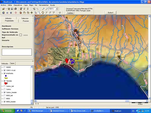
Screenshots:

General Features:

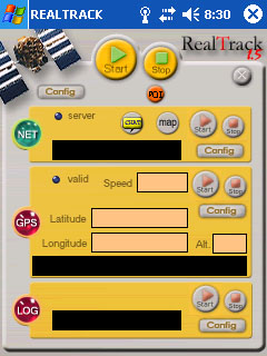
? Location and tracking in real time via GPS of the mobile devices of the fleet.

? Compatibility with PDA PocketPC.

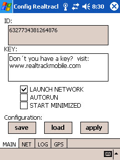
? Licence for 1 PocketPC mobile device.

? Data transfer in real time from the mobile device to the server.

? Show in cartography and Display in any software admitting GPS connection or through the COM port of the GPS locations.

? History creation and process at the control centre of the routes followed by mobile devices, so that the evolution of services in a given period can be subsequently studied.

? Display of the mobile device speed.

? Calculation of the distance covered by the mobile device.

? Definition of waypoints in route.

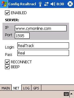
? CHAT: communication between the mobile device and the server via CHAT, this is carried out via a GPRS connection to the RealTrack server in the PC, thus enabling the message transfer at a minimum cost as compared with traditional SMS.

? Storing of GPS locations in a file (Data Logger).

? Persistent Bluetooth connection.

? Log transfer to the PC for their subsequent process, GPRS connection not needed.

? Display of the location, latitude and longitude in the mobile.

? Possibility to establish a name for the information points in real time and to communicate it to the server for its storing in its database.

? Link with dynamic GPS once it has been connected. If the mobile moves away and the connection with the GPS is cut, it will be automatically restored as soon as the mobile is within an appropriate distance radius again.


Summary of Realtrack Server features:


It opens and displays the following formats:

- Raster: TIFF/GeoTIFF, ECW, MrSID, JPEG2000, JPEG, IMG, BMP, BIL/SPOT, PNG, CADRG

- Vector: SHP, E00, MIF/MID, TAB, DXF, DGN, TIGER, GML, VPF, GDF, DLG, SDTS

- DTM format: ASCII GRID, FLOAT GRID, BT, DTED, and ADF

- Georeferenced images: GeoTIFF, World File, and TAB

Change of projection and Datum.

Zoom +/-, pan.

Scale defined by the user for the display and printing.

Project creation.

It handles in a fast and efficient way SHP files (up to 2 gigabytes!).

Control to add, remove, and reorganize the layers of the project.

Control to modify the appearance (Colours, styles, outlines, symbols, transparencies, etc.) of vector layers.

Control to add, erase, and modify points, lines and areas of a layer.

It shows Bar and Pie charts.

Inquiries by attributes.

Multi-field labelling.

Etc.

Screenshots:


Like it? Share with your friends!

If you got an error while installing Themes, Software or Games, please, read FAQ.
 

Supported operating systems: Pocket PC 2002, Windows Mobile 2003, Windows Mobile 5.0
 
Similar Software:

GPSSMSererGPSSMSerer
GPSSMSerer uses the GPS on your PocketPC to find your latitude/longitude/altitude and speed and creates a single blank SMS template. When the program gets its first lock then it creates an SMS with your GPS update location and a link to the Google.com mobile online street map
FON Access Points for Holy See (Vatican City State)FON Access Points for Holy See (Vatican City State)
FON Access Points for Holy See (Vatican City State) - FON offers you a new Points of Interest service (POIs). This allows you to download FONspots directly to your navigation device. What does that mean? You can download a Points of Interest file directly to your navigation device
GpsPort (Pocket PC)GpsPort (Pocket PC)
GpsPort (Pocket PC) is a TrekBuddy companion application for WM devices. It redirects COM port to TCP socket. This way TrekBuddy can access internal GPS where Java does not support serial port access (eg. Esmertec Jbed). TrekBuddy uses localhost (127.0.0.1) connection to read the NMEA data
CourseLogCourseLog
This is CourseLogV2, an EWE application that runs under Windows Mobile 2005, WM 6 using your GPS receiver to tell you where you are, how long and how far you go and where you have been. This version 2 provides a great improvement : it displays your position on a map
GPSEphemerisGPSEphemeris
GPSEphemeris uses the GPS on your PocketPC to download the hourly Ephemeris file from the GPS network. You can use this before you start other GPS applications to get a quicker GPS lock. NOTE: The ephemeris file expires after about 1 hour
Pocket PC Geocaching ToolsPocket PC Geocaching Tools
Pocket PC Geocaching Tools - Many tools in one program to help you while you are geocaching. What's included? * Open GSAK databases directly * HTML view * Field Notes * Hint decoder and decryption * Several coordinate functions * Solver * Transformer (Text to Digits, etc
FON Access Points for PakistanFON Access Points for Pakistan
FON Access Points for Pakistan - FON offers you a new Points of Interest service (POIs). This allows you to download FONspots directly to your navigation device. What does that mean? You can download a Points of Interest file directly to your navigation device
TasksGPSerTasksGPSer
TasksGPSer allows you to create date/time stamped tasks based on your current GPS. When you get a GPS lock then you can create a text task for the area. The program has a full featured file explorer that displays the tasks in order of distance from your current GPS. The map service is provided by Google
GPSLockererGPSLockerer
GPSLockerer keeps your GPS in your device active. When you tap the button the program will start the GPS and download the GPS data for your area. The program keeps the GPS active to allow for quicker fixes when you use another GPS program
Bluemapia MobileBluemapia Mobile
Bluemapia Mobile - View Maps, Search places and geotagged Wikipedia articles, GPS
 

Other Software by developer «CYMONLINE»:

Phone2GEarth S80Phone2GEarth S80
Phone2GEarth S80 converts GPS data directly to Google Earth® KML files. Phone2Gearth is an easy Nokia Series 80 GPS aplication that allows to log tracks which are directly saved as Google Earth KML files. New and usefull features like (Version 1.08): - English, Spanish, German and French languages. - Placemarks supported with timestamps in the track
REALTRACK MOBILE S60REALTRACK MOBILE S60
Fleet Management and mobile devices tracking
Phone2GEarth S60Phone2GEarth S60
Phone2GEarth S60 converts GPS data directly to Google Earth® KML files. Phone2Gearth is an easy Nokia Series 60 GPS aplication that allows to log tracks which are directly saved as Google Earth KML files. New and usefull features like (Version 1.08): - English, Spanish, German and French languages. - Placemarks supported with timestamps in the track

» show more


Comments on REALTRACK MOBILE POCKETPC:

Comments not found

Name:


Comment:


Enter text from image below:

Turn on images!


If you noted an error or download link is broken, please, report it via this page or use comments.
 

REALTRACK MOBILE POCKETPC is compatible with your device iPAQ hx2410/hx2415
 
 
© Pantich 2009 - 2025 All rights reserved.