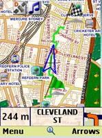
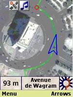
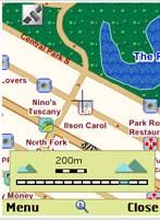
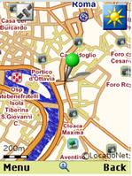
amAze (FLY) - amAze is a first of its kind free navigation and local search service. It is free to download and use and it contains wide coverage of maps including aerial photo in Europe, North America, Australia and parts of Asia and Africa.
With amAze you get all these options and more:
* Visual and voice guidance to any destination
* Search or define any location by its address
* Search and navigate to businesses listed in local search directories (where available)
* Present any required location on the map
* View and use dynamic high quality maps at various scales
* View and navigate over high resolution satellite images
* Calculate the fastest way between two locations
* Save and manage personal favorites list
* Worldwide weather
amAze enables to calculate the route of a journey to any address or point of interest. Bluetooth connection with a GPS receiver will indicate your location along the route with vocal and graphical guidance to your destination in the shortest possible way. amAze is a collaborative effort led by LocatioNet Systems Ltd., together with some leading vendors in the fields of mapping, local search directories and other geographically related content.
Like it? Share with your friends!
Supported operating systems:
Java ME, Java Nokia 240x320, Java SE 240x320
Similar Software:
FON Access Points for Maldives FON Access Points for Maldives - FON offers you a new Points of Interest service (POIs). This allows you to download FONspots directly to your navigation device.
What does that mean? You can download a Points of Interest file directly to your navigation device
Map My Tracks Map My Tracks - Map My Tracks turns your mobile phone into your personal training device that tracks your activities in real-time to share with others online. Map My Tracks is great for bringing a new insight into your sporting activity, it provides a competitive edge and makes training fun. Map My Tracks let your friends, competitors or parents know where you are right now
GpsMid Argentina GpsMid is a free, fully offline, vector based map application for your mobile phone. It displays your current position on a zoomable map and can be used to search for and navigate to roads or points of interest of your liking. As all data is stored in a compact binary format on your mobile phone you will incur no charges for extra data downloads
PositMe PositMe - lets you share your geographical position with your friends and family
FON Access Points for Canada FON Access Points for Canada - FON offers you a new Points of Interest service (POIs). This allows you to download FONspots directly to your navigation device.
What does that mean? You can download a Points of Interest file directly to your navigation device
GpsMid Afghanistan GpsMid is a free, fully offline, vector based map application for your mobile phone. It displays your current position on a zoomable map and can be used to search for and navigate to roads or points of interest of your liking. As all data is stored in a compact binary format on your mobile phone you will incur no charges for extra data downloads
RealReplay RealReplay - It's one of our inherent necessities to compete with other people and to compare ourselves to them. Unfortunately, in many situations this is impossible. The favored opponent might not have time, or maybe you only know him from television.
It would be perfect if we could compete with everyone, without being dependent on their time
GpsMid Puerto Rico GpsMid is a free, fully offline, vector based map application for your mobile phone. It displays your current position on a zoomable map and can be used to search for and navigate to roads or points of interest of your liking. As all data is stored in a compact binary format on your mobile phone you will incur no charges for extra data downloads
CloudGPS CloudGPS is Java ME mapping application using OpenStreetMap data and CloudMade services to provide
j2me FindMyCar j2me FindMyCar - Innovative software for mobile devices that uses the GPS signal to show signs that allow to reach a geographic location.
Suitable for various uses (eg. find car parked in a parking area or in an unknown city, finding a person (who has sent their coordinates) in a lovely beach, in a fair, in another boat, find an area of sea fishing, etc..)
Other Software by developer «LocatioNet Systems Ltd.»:
amAze (Sony Ericsson) AmAze is a first of its kind free navigation and local search service. It is free to download and use and it contains wide coverage of maps including aerial photo in Europe, North America, Australia and parts of Asia and Africa
amAze (Motorola) AmAze is a first of its kind free navigation and local search service. It is free to download and use and it contains wide coverage of maps including aerial photo in Europe, North America, Australia and parts of Asia and Africa
amAze (Sonim) AmAze is a first of its kind free navigation and local search service. It is free to download and use and it contains wide coverage of maps including aerial photo in Europe, North America, Australia and parts of Asia and Africa
amAze GPS (iPhone/iPad) amAze GPS includes turn-by-turn voice guided navigation with worldwide street maps, full topographic map coverage of the USA and satellite imagery for 200 major cities around the world. Initial download includes a free license to view maps and search for POI around the world
amAze (LG) AmAze is a first of its kind free navigation and local search service. It is free to download and use and it contains wide coverage of maps including aerial photo in Europe, North America, Australia and parts of Asia and Africa
amAze (Samsung) AmAze is a first of its kind free navigation and local search service. It is free to download and use and it contains wide coverage of maps including aerial photo in Europe, North America, Australia and parts of Asia and Africa
amAze (BlackBerry) AmAze is a first of its kind free navigation and local search service. It is free to download and use and it contains wide coverage of maps including aerial photo in Europe, North America, Australia and parts of Asia and Africa
amAze (LG) AmAze is a first of its kind free navigation and local search service. It is free to download and use and it contains wide coverage of maps including aerial photo in Europe, North America, Australia and parts of Asia and Africa
amAze (Android) AmAze is a first of its kind free navigation and local search service. It is free to download and use and it contains wide coverage of maps including aerial photo in Europe, North America, Australia and parts of Asia and Africa


")
")


")
")
")
")
")
")
")
")
")