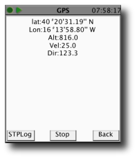
eGPSTrack is a GPS tracking application for mobile devices supporting J2ME connected with a Bluetooth GPS receiver. It isn't a navigator, the purpose is to be a positioning tool to be used in mountain to know where you are in each moment and to store the route that you are doing. Specially used for trekking, hiking and bike routes.
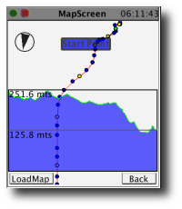
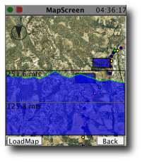
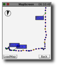
The application can load calibrated maps, (cartographic or satellite images), and show over it your saved route, current position and direction, offering thus a global vision of your trip.
You can generate maps to be used with eGPSTrack here.
What's New in This Release:
· General changes and improvements.
· Added support for GPS serial connected.
· Added preliminary support for internal GPS.
· Added Track Manager (new & load).
· Build-in exporters to GPX or KML.
· Map of elevations exported to KML.
· Added statistics screen.
· Multitrack visualization.
· Enabled background track logging.
· User Manual
Supported operating systems:
Java ME, Java Nokia 240x320, Java SE 240x320
Similar Software:
Maptales Mobile Maptales Mobile is a Java-based application for mobile devices that allows you to track your routes, add posts and tags and directly upload everything to Maptales.
Maptales Mobile has been created with ease of use in mind and provides a simple, straightforward interface for mobile storytelling
FON Access Points for Slovenia FON Access Points for Slovenia - FON offers you a new Points of Interest service (POIs). This allows you to download FONspots directly to your navigation device.
What does that mean? You can download a Points of Interest file directly to your navigation device
VGPS (Vietnamese GPS) VGPS (Vietnamese GPS) - was designed to use city street map on your ordinary mobile phone without the need of having GPS receiver or internet connection. VGPS does not require internal or external GPS receiver. However, if you have internal GPS receiver or external bluetooth GPS receiver, VGPS can work with your GPS receiver as well
VeloComputer VeloComputer - Transform your mobile phone into VeloComputer - an advanced cycling computer with cadence and GPS tracking. All you need is a mobile phone with accelerometer and GPS.
Strap your phone on a thigh with a sports armband holster with Velcro extension band or just put it in a pocket of your cycling tights
GpsMid Kenya GpsMid is a free, fully offline, vector based map application for your mobile phone. It displays your current position on a zoomable map and can be used to search for and navigate to roads or points of interest of your liking. As all data is stored in a compact binary format on your mobile phone you will incur no charges for extra data downloads
GpsMid Latvia GpsMid is a free, fully offline, vector based map application for your mobile phone. It displays your current position on a zoomable map and can be used to search for and navigate to roads or points of interest of your liking. As all data is stored in a compact binary format on your mobile phone you will incur no charges for extra data downloads
FON Access Points for South Korea FON Access Points for South Korea - FON offers you a new Points of Interest service (POIs). This allows you to download FONspots directly to your navigation device.
What does that mean? You can download a Points of Interest file directly to your navigation device
GpsMid Thailand GpsMid is a free, fully offline, vector based map application for your mobile phone. It displays your current position on a zoomable map and can be used to search for and navigate to roads or points of interest of your liking. As all data is stored in a compact binary format on your mobile phone you will incur no charges for extra data downloads
GpsMid Cyprus GpsMid is a free, fully offline, vector based map application for your mobile phone. It displays your current position on a zoomable map and can be used to search for and navigate to roads or points of interest of your liking. As all data is stored in a compact binary format on your mobile phone you will incur no charges for extra data downloads
bbTracker bbTracker is a simple application for mobile phones to create GPS track logs. It tracks ones movement and provides that data for later analysis. It is not meant as a replacement for full-featured GPS software that does display maps and do path-finding, but rather a simple tool that does one thing and does it well
Other Software by developer «Lluis Gesa Bote»:
not found
Comments on eGPSTrack:
Comments not found
If you noted an error or download link is broken, please, report it via this page or use comments.
Please, select device to check if eGPSTrack supports it


")


