Wayfinder Active (Java) is a free GPS service for mobile phones with a unique combination of maps, GPS recording and statistics, all designed for active people. With this service on your mobile, you get access to a world wide map and terrain maps for selected countries.
You record your route or training trail with just a click. Afterwards an e-mail is sent to you with the statistics and a map displaying your route. Moreover your activity is uploaded to the activeoutdoor.com community. Keeping track of your outdoor activities, physical progress and goals has never been easier, or safer!
The service is connected to mobile internet when you have coverage. If needed, for example when hiking on the mountain, you can preload the route on the phone memory. In other words – the application will always work!
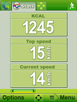
· Detailed statistics: Maximum, current and average speed. Distance, calories burned, altitude info and much more.
· Download routes and tracks from activeoutdoor.com directly to your mobile application. If you find an interesting route on the activeoutdoor.com community, just download it to your mobile and get going!
· Planning: You can plan your own routes on activeoutdoor.com or with Wayfinder Active and download them to your mobile phone before starting your outdoor activity.
· Compass: Find your way...
· Reverse route: Are you lost and want to get home fast? Just click “Reverse route” and go back the way you came.
· Search for closest routes: Looking for a running track or a mountain bike trail? Just search your surroundings, make a choice and you’re on your way!
Like it? Share with your friends!
Requirements:MIDP 2.0, CLDC 1.1
Supported operating systems:
Java ME, Java Nokia 240x320, Java SE 240x320
Similar Software:
GpsMid Australia, Western Australia GpsMid Australia (Western Australia) is a free, fully offline, vector based map application for your mobile phone. It displays your current position on a zoomable map and can be used to search for and navigate to roads or points of interest of your liking
FON Access Points for Togo FON Access Points for Togo - FON offers you a new Points of Interest service (POIs). This allows you to download FONspots directly to your navigation device.
What does that mean? You can download a Points of Interest file directly to your navigation device
Monitor-GPSFleet A service for tracking and monitoring the position of GPS devices using Google maps and OpenStreetMaps on the mobile phone
Tracker MyWay Outdoor Lite 1 month/300 tiles Tracker MyWay Outdoor Lite 1 month/300 tiles - MyWay Navigator Lite terrain navigation software in your mobile phone - 1 month license
MyWay Navigator Lite brings to you terrain, nautical and road maps covering several European countries. Features also include a smart compass and a location service to locate a friend
GpsMid Philippines GpsMid is a free, fully offline, vector based map application for your mobile phone. It displays your current position on a zoomable map and can be used to search for and navigate to roads or points of interest of your liking. As all data is stored in a compact binary format on your mobile phone you will incur no charges for extra data downloads
GpsMid UK, South Scotland GpsMid UK, South Scotland is a free, fully offline, vector based map application for your mobile phone. It displays your current position on a zoomable map and can be used to search for and navigate to roads or points of interest of your liking. As all data is stored in a compact binary format on your mobile phone you will incur no charges for extra data downloads
amAze (FLY) First of its kind free navigation and local search service. It is free to download and use and it contains wide coverage of maps including aerial photo in Europe, North America, Australia and parts of Asia and Africa
GpsMid Amsterdam-Rotterdam GpsMid is a free, fully offline, vector based map application for your mobile phone. It displays your current position on a zoomable map and can be used to search for and navigate to roads or points of interest of your liking. As all data is stored in a compact binary format on your mobile phone you will incur no charges for extra data downloads
FON Access Points for Cameroon FON Access Points for Cameroon - FON offers you a new Points of Interest service (POIs). This allows you to download FONspots directly to your navigation device.
What does that mean? You can download a Points of Interest file directly to your navigation device
Wayfinder Earth (BlackBerry) Wayfinder Earth (BlackBerry) - The world in your hand! Welcome to the ultimate experience of discovering the earth on your mobile device, for free.
How does it all work?
It's simple. Wayfinder Earth presents you with a 3D globe representing the planet earth, visible on the display of your mobile phone
Wayfinder Navigator Wayfinder Navigator transform your mobile phone to something more useful than the ordinary GPS. With millions of points of interest and even social networking features you have a real guide that you can take with you everywhere - wherever you travel in your everyday life
Wayfinder Earth (S60 2nd Edition) Wayfinder Earth (S60 2nd Edition) - The world in your hand! Welcome to the ultimate experience of discovering the earth on your mobile phone, for free.
How does it all work?
It's simple. Wayfinder Earth presents you with a 3D globe representing the planet earth, visible on the display of your mobile phone
Wayfinder Earth (UIQ3) Wayfinder Earth (UIQ3) - The world in your hand! Welcome to the ultimate experience of discovering the earth on your mobile phone, for free.
How does it all work?
It's simple. Wayfinder Earth presents you with a 3D globe representing the planet earth, visible on the display of your mobile phone
Wayfinder Earth (UIQ) Wayfinder Earth (UIQ) - The world in your hand! Welcome to the ultimate experience of discovering the earth on your mobile phone, for free.
How does it all work?
It's simple. Wayfinder Earth presents you with a 3D globe representing the planet earth, visible on the display of your mobile phone
Wayfinder Navigator (BlackBerry) Wayfinder Navigator (BlackBerry) - Wayfinder Navigator online and a GPS receiver transform your mobile device to something more useful than the ordinary GPS. With millions of points of interest and even social networking features you have a real guide that you can take with you everywhere - wherever you travel in your everyday life
Wayfinder Earth (Java) Wayfinder Earth (Java) - The world in your hand! Welcome to the ultimate experience of discovering the earth on your mobile phone, for free.
How does it all work?
It is simple. Wayfinder Earth presents you with a 3D globe representing the planet earth, visible on the display of your mobile phone
Wayfinder Earth (S60 3rd Edition) Wayfinder Earth (S60 3rd Edition) - The world in your hand! Welcome to the ultimate experience of discovering the earth on your mobile phone, for free.
How does it all work?
It's simple. Wayfinder Earth presents you with a 3D globe representing the planet earth, visible on the display of your mobile phone
Wayfinder SpeedAlert Wayfinder SpeedAlert gives you speed camera warnings and speed alerts in your mobile with over 22.000 speed cameras in 22 countries
Wayfinder Navigator (UIQ) Wayfinder Navigator (UIQ) - transform your mobile phone to something more useful than the ordinary GPS. With millions of points of interest and even social networking features you have a real guide that you can take with you everywhere - wherever you travel in your everyday life


")
")


")


")

")
")
")
")
")
")

")