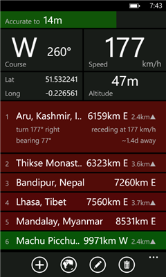
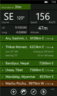
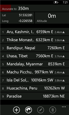
Distant tells you where places are in relation to where you are now. It lists your places in order of distance, and colour codes them so that it is easy to tell at a glance whether you are getting closer or further away. It also tells you how long it will take to get there if you keep moving at the current speed. Places can be entered visually using Bing Maps or directly by entering GPS co-ordinates.
Ever been on a long bus ride and wondered whether there are minutes or hours to go until you reach your destination? Ever had to negotiate with a cab driver who claimed that your destination was "very far away"? Once you got into the cab, did you wonder whether it was going in the right direction at all? Add a waypoint that represents your destination and track your progress in real time.
Going somewhere where you don't have mobile internet access or there is no coverage? Preload your waypoints while you still have access. Once this is done the app no longer requires data or even a signal. It works fine as long as you have a clear view of the sky and can get a GPS fix.
You can also use it to keep track of where you parked your car ...
Like it? Share with your friends!
If you got an error while installing Themes, Software or Games, please, read FAQ.
Supported operating systems:
Windows 10 Mobile, Windows Phone 7, Windows Phone 8
Similar Software:
A-to-B A-to-B is a Turn-by-Turn application built to demonstrate some of the capabilities of the ArcGIS API for Windows Phone.
Warning: The application is meant for demonstration purposes only! Do not rely solely on the suggested routes or instructions given by this application.
Features:
- Turn-by-turn routing. Sound notification when a turn is coming up
Movmap GPS Tracker Movmap GPS Trackeris a simple freeware GPS tracking program meant for WinCE/PocketPC machines. It can run on PNAs that use WinCE 4.2 .NET Core OS. See the movmap.txt file for details. Source codes for the program are also available
Sunnysoft MapView Sunnysoft MapView Map that works for you!
Perfect for trekking and at places with no GPS coverage!
Compact application for easy GPS navigation using only maps you need - comes without map contents and so it is fully up to you utilize maps of your choice
SupertweetGPS SupertweetGPS - SupertweetGPS allows you to send GPS based tweets to Twitter via SuperTweet.net. When you get a GPS lock enter the text and tap the button to send the Tweet with your current GPS. The program will send the tweet to Twitter.com with your current GPS. NOTE: To use Geolocation on Twitter in 'Settings/Account/Tweet Location' enable
FileGPSes FileGPSes - FileGPSes allows you to browse and execute the GPS tagged files and view them sorted in distance from your current GPS. You can also view and download the files placed on a Google.com map. This program uses "The Vincenty inverse formula for ellipsoids." (accuracy to within 0.5mm, or 0
RulerZIPer RulerZIPer allows you to find the distance from your current GPS to a US ZIP code. Start the GPS and when you get a GPS lock then enter the ZIP code. The program converts the ZIP code to GPS coordinates and displays the distance. This service is provided by USZIP
GPS Tuner Essentials Full Version with United States Basic Map Content GPS Tuner Essentials Full Version with United States Basic Map Content is designed specifically for off-road use: its large buttons, selectable tool window size, multiple Compass views and the built-in Tele Atlas map makes it extremely user-friendly and reliable
GPS4PPC GPS4PPC is an open source application, written with Basic4ppc that includes a set of tools for navigation and GPS data.
GPS4PPC supports:
- Converting coordinates between UTM and Lat / Lon.
- Converting coordinates in different datums.
- Calculating the distance and course between two coordinates.
- Show GPS data.
- Animated compass
Pocket Caddy Pocket Caddy - #1 Golf GPS app: 3D flyover of holes, yardage to greens, shot recording, stats, scorecard, hazard carry or lay up position. Positioning is shot to hole, not cart to hole. Free PC Analytics inc. 3D Google Earth replay with stats, and Free DIY Course Mapping software both available from website. No extra costs for courses
RoadMap RoadMap - RoadMap is a car navigation system. RoadMap displays a map of the streets, tracks the position provided by a NMEA-compliant GPS receiver, identifies the street matching this GPS position and announces the name of the crossing street at the next intersection
Other Software by developer «dixiak»:
not found
Comments on Distant:
Comments not found
If you noted an error or download link is broken, please, report it via this page or use comments.
Please, select device to check if Distant supports it