Geo32 for Windows Phone 7 is a GPS coordinate in a format that is easy to read, remember and transmit. Transmitting or receiving locations has never been simpler.
The Windows 7 Phone Geo32 application will translate the GPS of your position (or anyone else's) into Geo32 code.
The problem: You arrange a meeting with a friend in town. The friend comes to town but he's late and you have moved on. He can't find you despite the directions you give. You start by asking him to describe where he is, but you can't tell where they are.
The solution: You decide to ask for his Geo32 code. He launches the application and gets a code in seconds and sends it to you by sms. You enter the code in the Geo32 application and you immediately get the position. You can go to meet him or give him your own code so he can come to you.
Geo32 code is easy to remember and us. GPS coordinates are difficult to remember and coding errors are common. In some countries, the Geo32 code is sometimes no more than 4 letters!
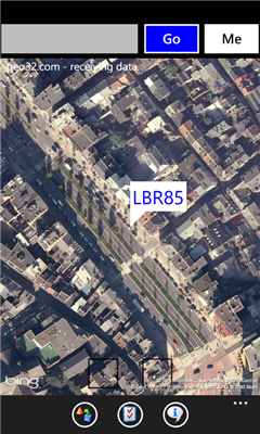
The geographic position (latitude and longitude) is rounded to 3 decimal places. The result is encoded on 78 bits for the absolute value and a variable number of bits for the relative value (the country). These values are then converted into string based on 32 letters and numbers.
Like it? Share with your friends!
If you got an error while installing Themes, Software or Games, please, read FAQ.
Supported operating systems:
Windows 10 Mobile, Windows Phone 7, Windows Phone 8
Similar Software:
bliinGPSXS bliinGPSXS is a free and easy software that sends your GPS-location to the bliin servers so you can be positioned Live! on the map in real-time. On bliin, users can locate and follow friends on a map in real-time, upload media: "Shares" - photos, videos, audio and text to Google Maps or other mapping services. Shares are geo-tagged to the location of capture
PathAway GPS SE PathAway GPS SE - GPS Navigation using your own maps! Convert any digital map, for use on your Pocket PC. Then, attach a compatible GPS (via bluetooth, cable, snap-on, or card) to your handheld, and you have a powerful GPS Moving Map navigation system
TextPOIs TextPOIs - TextPOIs can be used to create and edit compact text notes of any length and places the GPS tag at the end of the file. You can view the text files via your current GPS. You can view the text notes via your current GPS distance in real time and edit the text
LocBrowser Basic Edition LocBrowser Basic Edition - The LocBrowser Basic Edition assists mobile people in finding their route. It is especially well suited for traveling or outdoor activities like hiking or cycling. The LocBrowser Basic Edition is a comfortable and flexible viewer for digital maps. Additionally, it supports real-time navigation - when combined with a GPS receiver
GPS Tuner Essentials Full Version with Iberia Basic Map Content GPS Tuner Essentials Full Version with Iberia Basic Map Content is designed specifically for off-road use: its large buttons, selectable tool window size, multiple Compass views and the built-in Tele Atlas map makes it extremely user-friendly and reliable
GPSEmailer GPSEmailer uses the GPS on your PocketPC to find your latitude/longitude/altitude and speed and creates a blank Email template. When the program gets its first lock then it creates an email with your GPS update location and a link to the Google.com mobile online street map
Fusion GPS Fix Fusion GPS Fix - FusionGPSFix tries to deal with the anemic GPS on the Raphael, and any other post-WM5 device with slow GPS locking.
This app runs after install, and after soft-reset, and immediately starts up the GPS hardware through the WM5+ GPS API. It waits 5 minutes for a GPS lock, or it quits
GPark GParkS - The other day I was at a football game where I had to park on a golf course far from the stadium and ended up wandering around for 20 minutes trying to locate the car afterward
myRadar myRadar is a location aware radar application that makes use of Wunderground and Accuweather US web services to show real-time, animated Radar Images of your local area regardless of where in the US you might be. This application requires myLocation services to function automatically.
The program will install to /Program Files/myRadar
FON Access Points for United Arab Emirates FON Access Points for United Arab Emirates - FON offers you a new Points of Interest service (POIs). This allows you to download FONspots directly to your navigation device.
What does that mean? You can download a Points of Interest file directly to your navigation device
Other Software by developer «Active Up»:
Wallonie Traffic Wallonie Traffic vous permet d'afficher l'image de dizaines de cameras d'autoroutes wallones. Elles sont rafraichies toutes les 10 minutes environ