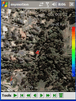
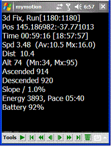
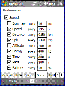
MyMotion - GPS route recording and playback with customizable spoken feedback of speed, distance and time. Uses a moving map to show progress as well as textual output. Maps can be generated from Google Earth installed on a PC using a map creation tool. Allows user to record a route then load it up as a reference for live comparison the next time it is traversed. Optional location tracking of GPS devices with GPRS or 3G, via the web and Google Earth or Google Maps.
· This software is free for personal use.
What's New in This Release:
· Performance Improvements, particularly UI responsiveness.
· User definable default file name format for track save.
· Add sensitivity enabling for menu items.
· Bug fixes: Fixed arrow direction. Fixed corruption with long (> 32 chars) file names in track files.
Like it? Share with your friends!
If you got an error while installing Themes, Software or Games, please, read FAQ.
Supported operating systems:
Windows Mobile 2003, Windows Mobile 5.0, Windows Mobile 6 Classic, Windows Mobile 6 Professional, Windows Mobile 6.1 Classic, Windows Mobile 6.1 Professional, Windows Mobile 6.5 Professional
Similar Software:
GPS Tuner Essentials Full Version with Germany, Austria, Switzerland Basic Map Content GPS Tuner Essentials Full Version with Germany, Austria, Switzerland Basic Map Content is designed specifically for off-road use: its large buttons, selectable tool window size, multiple Compass views and the built-in Tele Atlas map makes it extremely user-friendly and reliable
FON Access Points for Austria FON Access Points for Austria - FON offers you a new Points of Interest service (POIs). This allows you to download FONspots directly to your navigation device.
What does that mean? You can download a Points of Interest file directly to your navigation device
FON Access Points for China FON Access Points for China - FON offers you a new Points of Interest service (POIs). This allows you to download FONspots directly to your navigation device.
What does that mean? You can download a Points of Interest file directly to your navigation device
ExcelGPSed ExcelGPSed - ExcelGPSed allows you to create and view Pocket Excel files based on your GPS. When you create a new Pocket Excel file then the GPS location is appended to the end of the file. You can explore the Excel files via distance of your current GPS.
This program requires that you have both the 'BeanDLL
OpenStreetMap OpenStreetMap - Application similar to GoogleMaps but relies on OpenStreetMap.
OpenStreetMap an application similar to GoogleMaps but relies on OpenStreetMap.
It's finger friendly and showing the map on fullscreen.
GPS support and GSM triangulation (if no GPS device is present) is built in
PMWGPSTracking PMWGPSTracking allows you to plot your trip in a file (. KML).
The trace files can then be viewed and compared with Google Earth.
For each track you can define intermediate time (time stamp).
For each lap, the program calculates the duration, average speed and distance.
The trace files can be sent at regular intervals on an FTP server or an email address
Wizi SMS Location Telling your friends where you are or where you'll be meeting them was never so easy. Wizi SMS with Location is a light, fast and easy to use application that extends location sharing to standard SMS messages
SirfTech Pocket PC program for checking and setting practically all SiRF GPS settings and evaluating changes
StoreGPSed StoreGPSed - StoreGPSed allows you to make and edit text notes about stores based on your GPS. The program lists the stores via GPS distance from your current location. Tap on the store to view and edit the text notes for the store. You can also view and export a map of the stores on with the Google.com service.
This program requires that you have both the 'BeanDLL