MISOS (Mobile Information System Open Source) - MISOS (Mobile Information System Open Source) is a mobile information system written for mobile devices. With MISOS you can easily create your own location based information system for entering and getting location aware information
Fusion GPS Fix - FusionGPSFix tries to deal with the anemic GPS on the Raphael, and any other post-WM5 device with slow GPS locking.
This app runs after install, and after soft-reset, and immediately starts up the GPS hardware through the WM5+ GPS API. It waits 5 minutes for a GPS lock, or it quits
PictureMapperer - PictureMapperer can be used to tag pictures/videos from your camera with a Google.com map and GPS data. When the program detects a new picture/video in the folder then it downloads a Google.com map and appends it to the end of the image/video with GPS information
PictureGPSings - PictureGPSings can be used when you want to describe a set of pictures/videos from your camera and GPS information. Enter the text to place at the end of the images and the text will appended to the end of the images/videos taken with the GPS information.
This program requires that you have both the 'BeanDLL
TextPOIs - TextPOIs can be used to create and edit compact text notes of any length and places the GPS tag at the end of the file. You can view the text files via your current GPS. You can view the text notes via your current GPS distance in real time and edit the text
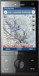
TextMapperer - TextMapperer allows you to create named text based GPS maps. When you get a GPS lock then you can create a new map and enter text for the area. When you save the text the map is downloaded and the text and GPS is appended to the end of the map with current GPS
ShoppingPOIs - ShoppingPOIs can be used to create store named POIs with a GPS tag. For each POI you can build a shopping list. The program uses the GPS on your PocketPC to show the distance each store is to you. You can add/edit/export the items on each store list
RulerPOIs - RulerPOIs can be used to create named compact POI GPS point files. You can use the GPS on your PocketPC to create a file and view the other files via GPS distance. You can also select 2 GPS points and place them into the ruler to view the metric/imperial distance.
This program requires that you have both the 'BeanDLL
VoicePOIer - VoicePOIer is a full-featured named voice recorder with GPS location tagger. You can make named voice recordings and the GPS location is appended to the end of the file. You can browse the files via GPS distance. Tap on the wave file to play it back.
This program requires that you have both the 'BeanDLL

")